
7 Day Forecast
A potentially historic snowstorm is poised to pummel Wisconsin Saturday night into Monday, according to forecasters.
Much of the state could see 10 inches or more of snow, with central Wisconsin expected to be hit the hardest with 2 feet or more in some locales, the National Weather Service said.
The totals could threaten the state’s 24-hour snowfall record of 26 inches set in Neillsville in Clark County on Dec. 27-28, 1904.

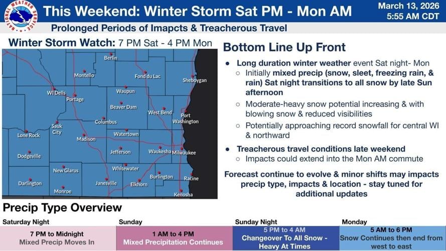
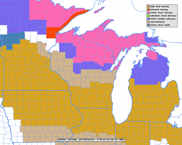
Most of the state is under a winter storm watch, starting as early as 7 p.m. Saturday and ending as late as 4 p.m. Monday.
On Friday, a smaller storm was dumping several inches of snow in northern Wisconsin and bringing high wind warnings to southern Wisconsin until 4 p.m. for west winds gusting to 60 mph.
A State Journal reporter driving into work before daybreak Friday from the village of Oregon saw virtually every garbage and recycling can left at the curb for collection day in Oregon blown over. Authorities were dealing with numerous calls for trees down and other wind-related problems.
People are also reading…
In southern Wisconsin, the storm will begin with mixed precipitation Saturday night through Sunday afternoon.

NWS lead meteorologist Kevin Wagner said precipitation types generally will be mostly rain along and south of a line from Darlington to Janesville to Milwaukee, mostly snow along and north of a line from Wisconsin Dells to Waupun to Oostburg, and predominantly sleet and freezing rain in between, which includes Madison.
Areas that start as snow will see the largest snow totals, with areas that go the longest before switching to snow seeing the lowest snow totals.
Wagner cautioned that a north or south shift in the system would cause the areas of rain, snow and freezing rain/sleet to shift.
By late Sunday afternoon, the precipitation will transition to all snow for southern Wisconsin, continuing into Monday with moderate to heavy snow possible and north to northwest winds gusting to 30 to 40 mph creating blizzard or near-blizzard conditions featuring substantial blowing snow and visibilities as low as a quarter-mile.
For southern Wisconsin, the chance for a foot of snow or more is 28% for Janesville, 38% for Milwaukee, 43% for Madison, 55% for Wisconsin Dells, and 60% for Fond du Lac.
Madison is forecast to possibly see around an inch of snow and sleet Saturday night, less than an inch of snow and sleet Sunday, 4 to 7 inches of snow and sleet Sunday night, and Widespread blowing snow into Monday morning, according to the Weather Service.
Highs should be near 42 Friday, 39 Saturday, and 43 Sunday, with lows around 27 Friday night, 31 Saturday night, and 17 Sunday night.
Quiet weather is forecast to follow, with highs Monday through Thursday moderating from 22 to 23 to 39 to 47, and lows Monday night through Wednesday night around 2, 14 and 27.
Wisconsin Dells is predicted to possibly see 2 to 4 inches of snow and sleet Saturday night, 4 to 7 inches of snow and sleet Sunday, 4 to 7 inches of snow Sunday night, and areas of blowing snow Sunday, with snow ending by 1 p.m. and totaling 10 to 18 inches.
La Crosse is forecast to possibly see 3 to 5 inches of snow Saturday night, 8 to 12 inches Sunday, and 4 to 8 inches Sunday night, for a total of 15 to 25 inches.

Eau Claire is predicted to possibly see 8 to 12 inches of snow Saturday night, 12 to 18 inches Sunday, and 2 to 4 inches Sunday night, for a total of 22 to 34 inches.
Wausau could possibly see 5 to 9 inches Saturday night, with snow that will be heavy at times continuing through Sunday night but no totals provided.
Green Bay is forecast to possibly see 4 to 8 inches Saturday night, with snow that will be heavy at times continuing through Sunday night but no totals provided.
Milwaukee is expected to possibly see 1 to 2 inches of snow and sleet Saturday night, less than a half-inch of snow Sunday, and 1 to 3 inches of snow and sleet Sunday night.
Kenosha is forecast to possibly see less than a half-inch of snow Saturday night, a half-inch to three-quarters of an inch of rain Sunday, and 1 to 2 inches of snow and sleet Sunday night.
Madison has had 41.7 inches of snow this snow season (since July 1), 4.1 inches below normal.
Nearly every part of the U.S. is getting walloped by wild weather or just about to be, the Associated Press reported.
Days of downpours have begun in Hawaii. The Southwest will soon bake with day after day of record 100-degree-plus heat never seen this early. And this weekend's huge snowstorm and accompanying polar vortex-induced cold will invade the Midwest and East.
Former National Oceanic and Atmospheric Administration chief scientist Ryan Maue said he expects extreme weather in all 50 states.
Some forecasts see 98 in Phoenix on Tuesday, followed by 103, 105 and two days of 107. In 137 years of record-keeping, Phoenix never hit 100 before March 26 and usually hit its first 100-degree day in early May, according to the Weather Service.
Underlying this is a jet stream gone wild, Maue and meteorologist Marc Chenard of the National Weather Service’s Weather Prediction Center in Maryland said.
The jet stream is the river of air that moves weather from west to east on a roller coaster-like path. Usually, the plunges are as mild as a kiddie roller coaster. But now that jet stream is barreling down near-vertical, scream-inducing drops, followed by straight-up ascents.
“Which means you get a lot of extremes next to each other,” Maue said. Storm fronts coming from the Pacific hit that high pressure heat dome in the Southwest and are pushed north to climb that mountainous jet stream peak, “grab access to that cold air reservoir up there” and bring it back down south down the other side of the hill, he said.
Worst blizzard ever: Remembering the 'Big Snow' of 1881
Snow bank in Sheboygan

Several people stand on a large snow bank on 8th Street in Sheboygan, looking north, on March 4, 1881, after the big snowstorm. Signs hanging over the sidewalk attached to the brick buildings read: "Paint, Oil & Glass," and "American Express, Custom House, Telegraph Office."
Just enough room

Three men stand in front of a locomotive with a snow thrower attached to the front of the engine. The snow trough is barely wider than the train but equally as tall. The photo -- from the Chicago, Milwaukee and St. Paul Railway Co. collection -- was likely taken during the big snowstorm of 1881.
Massive drifts in Sheboygan

The view March 4, 1881, from the corner of 7th Street in Sheboygan after the "big snow."
Scene in Whitewater

The scene in Whitewater after a massive snowstorm hit Wisconsin between Feb. 27 and March 3. According to the Whitewater Register newspaper, "Nothing like it was ever seen before in Wisconsin...". The photo was probably taken from the second story of the Bowers Opera House.
After "the big snow"

The scene in downtown Sheboygan on March 4, 1881.
Buried railroad tracks

Men work to dig out train tracks in Racine after the big snowstorm in March 1881.
Digging by hand

Another view of men digging out the railroad tracks by hand in Racine County in March 1881.
10 to 12 feet high

A stereograph of snow-covered 8th Street in Sheboygan. The back of the photo said the average height of the snow was 10 to 12 feet.
Posing among the banks

A stereograph of people posing among snow banks in Sheboygan on March 4, 1881.
Headline from the March 4, 1881, State Journal

A headline on the front page of the State Journal on March 4, 1881, calls attention to the storm and the problems it brought statewide.
State Journal front page March 4, 1881