

OCEANS OUT OF WHACK
Atlantic sees potential for record calm while Pacific activity is up

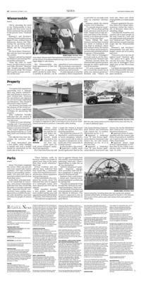
Waves crash on San Francisco Beach in the aftermath of Hurricane Polo on Sept. 29 in San Carlos, Sonora state, Mexico.

HURRICANE SEASON
The 2026 hurricane season has been remarkable, from the potentially record-breaking calm in the Atlantic Ocean to the hyperactive eastern and central Pacific Ocean.
Only seven tropical storms have formed in the Atlantic, while 18 tropical storms and hurricanes have formed in the Pacific. In a normal year, the Atlantic and the eastern Pacific hurricane basins see similar activity, with 14 to 15 named storms, including seven to eight hurricanes, by the time the season ends on Nov. 30.
This year, the Atlantic hasn't produced a single hurricane, while the eastern Pacific has already produced nine.
A few of the storms that occurred in the two basins originated in Africa and were influenced by the same powerful climate phenomenon, El Niño. But the results have been very different, with fierce hurricanes in the Pacific and unremarkable tropical storms in the Atlantic.
Meteorologists and climate scientists closely watched the progression of these tropical waves and storms from their origins to their final destination using a fleet of satellites operated by the National Oceanic and Atmospheric Administration.
More than 60 years after satellites began helping observe hurricanes, scientists are still learning more about how and where tropical waves begin and how they develop and move. They watch as waves form in the Ethiopian mountains, over the Sahara or off the African coast, and then track them across the Atlantic and sometimes well into the Pacific.
This summer, there wasn't a lot to see in the Atlantic. Tropical waves that appeared were disrupted by shearing winds related to the El Niño. When Tropical Storm Gonzalo formed in the Atlantic on Sept. 25, it was only the season's seventh named storm, and it formed three weeks later than typical for the storm named with the letter "G" each season.
Meanwhile, the central and eastern Pacific had seen 18 named storms as of Sept. 30, according to the National Hurricane Center.
Conditions in both basins are at least partially linked to the "super El Niño," said Stacy Stewart, a former hurricane specialist at the National Hurricane Center, now retired and teaching meteorology courses at Embry Riddle-Aeronautical University.
However, while the relative calm in the Atlantic can be primarily attributed to El Niño, it's not the only thing keeping hurricane activity tamped down, Stewart said. A drought in Ethiopia has also contributed to the quiet Atlantic season, as have dry air and Saharan dust.
Hurricane birthplace
Residents across the Atlantic's hurricane basin may not be aware that many tropical waves originate over the Ethiopian Highlands, Stewart said.
The waves are among dozens that develop and move off Africa into the Atlantic Ocean each year, according to Kelly Núñez Ocasio, an assistant professor in the department of atmospheric sciences at Texas A&M University.
Most of the waves that move off the coast of Western Africa never become tropical storms or hurricanes. But for the storms that do develop, waves that originate over the Ethiopian Highlands are the ones more likely to become hurricanes, Núñez Ocasio said.
Both Fausto and Genevieve, two of the Pacific hurricanes this summer, developed from areas of disturbed weather that rolled off the hot, dry African continent near the island nation of Cape Verde, according to NOAA. The waves traveled westward, crossed Central America and eventually found favorable conditions over the eastern Pacific, where they strengthened into hurricanes.
The drought in Ethiopia meant a lack of the kind of thunderstorm activity needed to produce the big storm clusters and tropical waves that are "strong enough to survive the trek across the African Sahel region and resist shear conditions" over the Atlantic, Stewart said. "June and July 2026 brought some of the driest conditions on record, with rainfall deficits reaching 40% to 70% in northern, eastern, and central Ethiopia."
Quiet in the Atlantic
"The last time we went this long without an Atlantic hurricane was in 1914," said Phil Klotzbach, a senior research scientist with the Department of Atmospheric Science at Colorado State University. "Of course, who knows what we really had for activity in 1914?"
"I really think the big story this year has been record high levels of vertical wind shear across the tropical Atlantic," Klotzbach said. "The constant shredding of any system trying to develop has been a common theme so far this year, and as Yogi Berra used to say, 'it's getting late early.' While we certainly can't rule out a late-season hurricane or two, this season is certainly shaping up to be one of (if not the) quietest seasons since 1950 (when reasonably reliable records began)."